Geography & Geology
Geography
Iceland's situated between 63º30’ and 66º30’ northern latitude and 14º and 25º western longitude. It's at 800 km north of Scotland, 970 km away from Norway and 290 km from Greenland's East cost.
It stretches 500 km from East to West and 300 km from North to South, what multiplies to a surface of 103.000 km2. At least at the moment. Due to the volcanic activity Iceland is constantly growing. But more on that later.
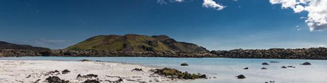
Half of Iceland's terrain is made up of deserted plains. The rest is widely comprised of lava fields, glaciers and sandy deltas in the South. Almost 3.000 km2 are made up of either lakes or rivers. Only a fifth of the whole surface of the country is cultivable.
With 2.119m above sea level the Hvannadalshnúkur in the country's highest mountain. It's to be found in the East, covered by the Ormfajükull glacier. The average altitude of the island is 400m.

Geology
What makes Iceland unique and thus so attractive for visitors is it's geological origin. Iceland is sitting right on the Mid-Atlantic Ridge, the place where the North American and the Eurasian (tectonic) plates meet. Geologically spoken it is thus a schizophrenic country: one part (the Eastern one) belongs to Europe (where it geographically or rather politically belongs to), the other part (the Western one) sits on the American Continent.
The two plates are in a very slow but constant movement away from each other. This does not only result in frequent earth quakes, the fissure between the plates is the source for ongoing volcanic activity. Magma from the Earth's core makes its way through it forming new land above.
The creation of Iceland started about 16 million years ago, which is – geohistorically spoken – very recent. Iceland is in fact one of the youngest landmasses in the world. With a little exception. In a place in the East of the country rocks dating back 50.000 million years have been found. This suggests that there must have been land just above the hot spot when the volcanic activity started.
The hot spot underneath Iceland is the most powerful and active one on Earth. Consequently most of all volcanic activity in the past million years has been taking place here. And also in recent years. Apart from eruptions in the country's interior a whole new island appeared in the years between 1963 and 1967 just south of the Vestmann Islands - Surtsey. The eruption of the (unpronounceable) Eyafjallajökull in 2010 is for sure still on everybody's mind.
But not only the volcanic activity shaped the island's face to the form we see today. Much of the peculiarities of the Icelandic landscape are a consequence of the last ice age. 10.000 years ago Iceland was entirely covered by a thick sheet of ice, much like the biggest part of Greenland is today. The movement of the glaciers grounded the mountains to its actual shape, digging fjords and valleys out of the volcanic rock.
Geothermal activity
Apart from moulding the country the volcanic activity is also the cause for the variety of geothermal phenomenons on the island. Hot springs, geysirs and fumaroles are not only tourist attractions but play an active role in the life of the locals.
Hot springs
A "hot" spring need by definition not be “hot”, 5°C above the temperature of the surface is enough to receive the denomination. "Lukewarm spring" – though more correct - would admittedly not sound as appealing. Bathing in those thermal waters is a welcoming delight for locals and tourists. Its mineral richness makes it popular for all kinds of health treatment.
Apart from the relaxing leisure time experience the hot springs in Iceland are put to a very practical use. They heat 87% of all Icelandic households as well as providing them with hot water. This is not only convenient (and cheap) it is also extremely environment friendly.
Apart from the direct use the hot water drives the turbines of the many geothermal power plants, which produce approx. 26% of the country's energy consumption. The remaining electric demand is (almost entirely) met by hydroelectric plants. Iceland is probably the only country in the world running almost completely on renewable energies.
The abundance of natural resources keeps electricity prices low - a fact not only appreciated by the Icelanders but also by high energy consuming industries. Aluminium fabrics, for instance, have found Iceland to be a great place for building their melters, scratching away on the country's valuable "green" image. No wonder, the melters are not welcomed by every one.
Swimming or relaxing in the hot pots is an integral part of Icelandic culture. Apart from the basin actually dedicated to swimming (in a sporty sense) every swimming pool in Iceland has at least one natural or artificial hot pot. The hot pot in fact is for Icelanders what the sauna is for people in other Scandinavian countries. You go there to meet friends or for an after-work-dip with your colleagues. It's not uncommon to seal important business contracts while sitting half naked in the comfortable warm waters. Finally, they are the place for meeting new people. And for fierce political discussions.
Iceland's probably most famous thermal pool is the Blue Lagoon. It's situated not far from Keflavik airport, at a 40 minutes drive from Reykjavik's city centre.
Better than the official swimming pools in the eyes of many are though the natural hot springs and rivers to be found in various parts of the country close to the Mid Atlantic Ridge, like for example the area of Landmannalaugar.
Geysir – the one and only
Did you know that there is only one Geysir in the world? Or, let's say: one geysir named Geysir. Or: one geysir that gave the name to all other geysirs in the world? Yes. And obviously it is to be found in Iceland!
Geysir (the Geysir!) is located on the famous Icelandic Golden Circle, in Haukadalur in the South East of the country. Once upon a time it was very active, spitting out its (10-80m - depending on the source..) water fountain in regular intervals of 24-30 hours. At some point, though, it stopped. Some say it happened because people kept throwing soap and other stuff into it to provoke an eruption. This actually can be a reason for a geysir's death. Among others. The repeating eruptions can cause the tube that leads from the deeper water basin to the surface to widen, destroying the bottle neck - one of the essential shape peculiarities necessary for a geysir to exist (read more below).
Earthquakes can change a geysir's structure causing it to die (and also to revive again, as in fact an earthquake in the year 2000 brought our geysir back to life, for a short time). Nearby geothermal power plants can also be a reason as they tend to lower the groundwater level.
But don't worry, Geysir isn't (or wasn't) the only one of its kind in Iceland. Another especially interesting one happens to sit right next to it: Strokkur. With its 20-30m high fountain it can be considered a worthwhile replacement. What makes it even more charming than its dead and during lifetime lazy neighbour (eruption cycle of 24-30 hours) is the fact that Strokkur erupts in tourist friendly intervals of 10 minutes. Make yourself a picture on Strokkur's live webcam: http://www.livefromiceland.is/webcams/geysir/
How a geysir works
A geysir does at first sight not differ from other ponds fed with hot water. What makes it different, though, is that the water reservoir below narrows to the form of a tube creating a bottle neck. The colder water on its top acts like a natural barrier keeping the heated water below from escaping upwards. Even steam bubbles created while the water heats up are trapped. Only when the water reaches a temperature above boiling point some lonely gas bubbles manage to find their way up pushing away some of the cooler water. This results in a just slight reduction of the pressure but enough to make the whole thing go off in a blast, catapulting the water above in a fountain into the air. The process repeats itself in cycles of minutes or hours depending on location and structure of the geysir.
Volcanoes
Holes in the earth spitting out hot liquid is a somewhat geological pattern in Iceland. The topic gets more interesting when the liquid in question is not mean water but melted lava and the hole actually a full grown mountain.
Iceland has some 130 of those firy mountains (ok, let's call them volcanoes) whereof 20 have been more or less active since the island was inhabited in the late 800th. Most of them are to be found on or close to the Mid-Atlantic-Ridge but there are also some erratic ones spread around the country. The currently most active volcano is the Hekla, situated at approx. 110 km east of Reykjavik. It last erupted in February 2000.
In medieval times the Hekla was, by the way, considered the door to hell. Some say the expression "What the heck!" has its origin here.
Although most of the eruptions of Icelandic volcanoes go unnoticed by the extra-Icelandic public the one of the Eyjafjallajökull (no, we won't give you a hint on how to pronounce it) in 2010 did. The reason for this unusual international attention were the unusual amounts of emerging ash which considerably hampered international air traffic for weeks.
The Snæfells is another (more pronounceable) volcano that brought it to international fame. The (dead) volcano on the peninsula of Snæfellsnes in the West of the island appears in Jule Verne's famous book "Journey to the centre of the earth". It there is the gate through which the book's protagonists enter the Earth's interior to at the very end be spilled out by the Italian crater Stromboli on the opposite side of the hemisphere.
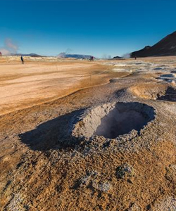
Fumaroles
Finally there is a third type of openings through which the earth releases the pressure of its agitated bowls in Iceland: Fumaroles.
In this case the emission is not a liquid one but comes as a mixtures of steam and gases. The biggest attraction of the fumaroles is its smell. Some of the fumaroles are made up of water steam only and thus smell of nothing. By far the majority, though, contain some type of sulphur compounds, giving it the smell of rotten eggs. Fumaroles don't have a distinctive shape. Some have the form of chimneys but more often than that they are just steaming holes or fissures in the rock.
All those geological phenomenons can by the way be viewed in the national parks of þingvellir, Gullfoss and Geysir which lie on the famous Golden Circle. Book your excursion here!